


🧐 What is onx offroad: trail maps & gps and How does it work?
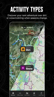
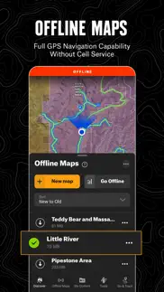
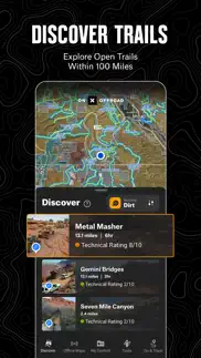
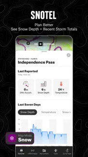
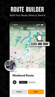
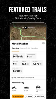
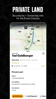
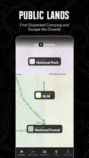
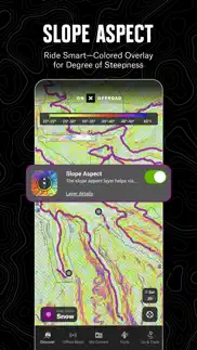
GPS mapping App that lets you easily find the off-road trails you're looking for—whether you want to discover what’s open nearby or explore somewhere new. Filter 615K miles of nationwide trails by accessibility for 4x4, SxS, dirt bikes, moto, ATV/Quads, Overland, and snowmobiles. ▶Navigate Without Cell Coverage Save Offline Maps to bring your custom maps and adventure along when you're outside cell coverage on the trail. With the onX Offroad App, you turn your phone into a handheld GPS device using your phone's internal GPS. Navigate offline by following the blue dot to always know how to get home–wherever home is that night. ▶Adventure is Tap Away with Our Library of Map Data With map data sourced from USFS, MVUM, BLM, and NPS, our color-coded basemap includes off-road trails, Public Land boundaries, and recreation points to let you quickly scan for open routes near you and locate dispersed camping or campgrounds. Tap anywhere on the map to find hiking trailheads, trailer parking, non-ethanol fuel stations, boat launches, fishing access, and more. Scout the landscape and visualize mountains by viewing your maps in 3D, topo, satellite imagery, or a hybrid. ▶Private Property Maps With Boundaries-Elite Only Make your maps Elite to discover more off-road access with private property boundaries and data for the whole country. Always know where you can legally off-road and camp, and find out who owns OHV trails or the property next to a trail easement with our Private Land Map Layer. ▶Plan, Record, Save, and Share Your Trips Drop Waypoints to save points of interest on you maps and share locations with others. Go and Track records and saves your speed, distance, location, and leaves a breadcrumb trail so you’ll always find your way back and can share your ride with friends and family. ▶Off-Road Trails In Your Vehicle’s Dash Carplay compatibility lets you enjoy hands-free navigation and view off road trails and maps in-dash. ▶ PREMIUM AND ELITE OFFROAD APP FEATURES: ▶Private Land Layer-ELITE ONLY: Nationwide private property maps and land boundaries, ownership information, and acreage ▶985 million acres of Public Land across the U.S. ▶615,000+ miles of motorized roads and trails off-road for 4x4, Side-by-Side, dirtbikes, dual sport,, ATV, Quads, Overlanding, and snowmobiling ▶24K topographic maps and 3D maps for the entire U.S. ▶550,000 Recreation Icons for points of interest including: ▶Gas / non-ethanol fuel stations ▶Trailer parking ▶ Backcountry cabins and lookouts ▶Swimming and fishing access ▶Hiking and biking trail heads ▶Designated camping areas, campsites, campgrounds ▶Hot Springs, Breweries, and much more ▶Save unlimited Offline Maps for offline navigation without cell service ▶Mark points along your route with photo Waypoints to plan and share your adventures. ▶Track your trips (location, speed, distance, and elevation) to know where you came from, how to get back, and share your ride with friends. ▶Locate free camping, car camping, and dispersed camping ▶Active and historic wildfire layer to help plan safe adventures ▶ Localized weather conditions and 7-day weather forecasts ▶Line, distance, and area measuring tools ▶Coordinates and compass for anywhere you scroll or roll ▶ TERMS OF USE: https://www.onxmaps.com/tou ▶ FEEDBACK: At onX it’s our mission to help you find new places to explore with confidence, knowing you have onX Offroad with you. If you have any trouble or have an idea on what you’d like to see in the app next, please contact us at support@onxmaps.com. We’d love to hear from you.

40 Best Navigation Apps like OnX Offroad: Trail Maps & GPS 🔥 Top Picks for 2024
A guide to the best alternatives for onx offroad: trail maps & gps. What are the top navigation apps like onx offroad: trail maps & gps for 2024? Find popular navigation like onx offroad: trail maps & gps. Below are the most similar navigation apps we found. Discover the top 40 competitors to onx offroad: trail maps & gps.